Home Dolomites Summer Val Gardena Hiking Dolorama 4. Stage
 Val Gardena
Dolorama 4. Stage
Medium
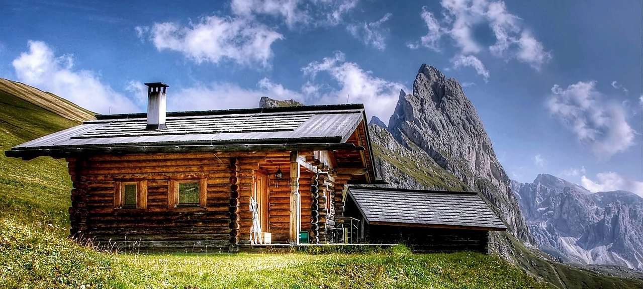
The Dolorama Track: Hiking in the realm of the Dolomites
A 4-day hiking tour in a breath-taking Alpine landscape with spectacular panoramic views, from Rodenecker mountain pastures to Laion/Lajen
The beautiful peaks of the UNESCO World Heritage site of the Dolomites are always in view! The Dolorama Route runs in four stages, from the Rodenecker mountain pastures to the village of Laion/Lajen – an unforgettable hiking experience through the valleys and mountains of the Dolomites.
The 61-km long Dolorama tour starts gently and then passes through the unique varied landscape of the Dolomites. Leaving the rich pastures of the Rodenecker and Lüsner Alm pastures, the route reaches the rugged rock formations of the Aferer and Villnösser Geisler, leading through pastures and meadows down to the village of Lajen/Laion. A spectacular panoramic view is to see along the entire tour on the horizon: the unique high rock formations of the Dolomites. First, the impressive Peitlerkofel in Funes/Villnöss, close to the Gömajoch ridge in the Puez-Geisler Nature Park comes into view, and then the Raschötz mountain pasture, withe the view extends to the peaks of Langkofel, Plattkofel and Schlern.
The Dolorama trail consists almost entirely of forestry paths and hiking trails , and is only crossed once by a road. Along the way there are many rest areas and panorama points to stop at: for example, the prehistoric settlement site at Astmoos on the Luson/Lüsner Alm pasture or the alpine pastures of Raschötz. For those who want to undertake the 4-day tour in stages, there are many access paths and descents along the entire route. These, as well as the starting point and target destination, are all easily accessible by public bus.
There are many Alpine huts along the way, offering refreshments and accommodation.
All in all: a pure experience of the Dolomites !
Dolorama - Total Distance
» Starting point: Zumis car park, Rodengo/Rodeneck
» Endpoint: Laion/Lajen
» Route: 61 km | ascent: 2,356 hm | descent: 3,004 hm
» Walking time: approx. 19 hours 15 min.
Stages of the Route:
» Stage 1: from the Zumis car park at the Rodeneckker/Lüsner Alm mountain pasture to the Maurerberghütte hut (ca 6.30 h)
» Stage 2: from the Maurerberghütte mountain hut to the Schlüterhütte alpine hut (ca. 4.45 h)
» Stage 3: from the Schlüterhütte alpine hut to the Raschötz shelter hut (ca. 5 h)
» Stage 4: from the Raschötz shelter hut to the village of Laion/Lajen (ca. 3 h)
Durch das Grödnertal nach St. Ulrich.
Raschötzhütte bis Lajen
Strecke: 9,7 km, Aufstieg: 33 hm, Abstieg: 1.106 hm, Gehdauer: ca. 3 Std.
Mit Blick auf die beherrschende Langkofelgruppe verlässt man nach der Heiligkreuz-Kapelle die Dolomitenlandschaft (Abstecher zum Außerraschötz-Gipfelkreuz 2281m, fabelhafte Rundsicht), um durch Fichten- und Lärchenwälder dem Eisacktal zustrebend, das schöne Bergdorf Lajen zu erreichen.
Die Dolorama-Route führt bei der Heiligkreuz-Kapelle (2198m) zum felsbruchartigen Außerraschötz-Westabhang, Markierung 35 führt dort im Blockgelände in nördlicher Richtung absteigend, zu den Bergwiesen am flachen Tschatterlin Sattel (1870m). Die Wanderung verläuft nun westwärts auf Forstweg zur nahen Ramitzler Schwaige (1815m), weiterhin auf Wirtschaftsweg zur Unterpulghütte (1548m) und auf längerer Strecke, immer Nr. 35, im Wald ständig absteigend, oberhalb von Dörfchen Tschöfas vorbei, durch die Felder nach Lajen (1093m, Linienbus Verbindungen).